• Get involved.
    We want your input!
    Apply for Membership and join the conversations about everything related to broadcasting.

    After we receive your registration, a moderator will review it. After your registration is approved, you will be permitted to post.
    If you use a disposable or false email address, your registration will be rejected.

    After your membership is approved, please take a minute to tell us a little bit about yourself.
    https://www.radiodiscussions.com/forums/introduce-yourself.1088/

    Thanks in advance and have fun!
    RadioDiscussions Administrators

KILT 610 now transmitting from KNTH site

KILT 610 is now transmitting from the KNTH 1070 towers, albeit with an STA for reduced power as well as an omnidirectional signal. Appears they lost use of the legacy site on West Road near I-45. New site owners finally kick them off the land? They are supposedly close to completing work on the final diplexed setup, eventually running 2.7kw days from five towers and 2.5kw nights from six towers.

STA filing states: “Audacy License LLC has been informed that the licensed facility of KILT will not be available for use after this weekend. Therefore special temporary authority for operation nondirectionally with 915 watts full time from the #1 tower (ASR 1039493) at the site of the outstanding construction permit BP-20211101AAI is requested. The filtering and detuning apparatus for the implementation of the permit facilities has been installed and tuned and nondirectional operation at this location will be straightforward. This tower is 111.7 degrees tall at 610 kHz.”

The STA request is dated February 2 and was approved today, 2/13. Direction finding at my NW Harris County location confirms the signal switch (the two sites are 90 degrees apart in direction for me, so easy to determine.)

Perhaps Chuck Tiller can fill in some more info from a KNTH perspective?
 
Remember that half the power is not "half the coverage". A 50% power reduction gives about a 25% reduction in coverage, all other things (tower height, ground conductivity at new site, etc,) considered.
 
Remember that half the power is not "half the coverage". A 50% power reduction gives about a 25% reduction in coverage, all other things (tower height, ground conductivity at new site, etc,) considered.
The new 610 site is also six miles north of the old one, so curious to see how reception will be affected in the southern half of the market, given the power reduction.
 
As far as KNTH is concerned, we had to go off the air for a few hours last week, as the testing began. There are a couple of times when KNTH had to go Non-D 2.5KW from tower 5. My thoughts on KILT 610 are subjective. After all, I spent many years there getting phone calls as far way as Victoria and Corpus Christi. KNUZ 1230 was forced to change to a country format in 1973. KNUZ with it's 1000 watts day and 250 watts at night could not compete with the mighty 5000 watts of KILT. To be on both the AM & FM simulcast was a treat, too. Hence: "12 in a row, FM 100 K-I-L-T 6-10 up and down the Texas Gulf Coast..." I know, I know, it's only supposed to cover it's Metro area. The mighty has fallen.
 
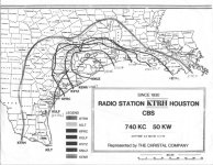
Here's a map comparing the coverage of the larger Houston radio stations in 1974. This was still posted in the KTRH newsroom in 1985. It was originally a color map, with the coverage contours for each station in different colors, but there weren't color copiers back then. Obviously it's designed to show KTRH's extensive coverage along the Gulf Coast, but, at least in Texas, KILT was a close second, particularly nearer the coast and just to the east of Austin.

I annotated the map to show the call letters that were current in 1985. Mapping to frequencies:
KTRH - 740
KILT - 610
KPRC - 950
KULF (KKBQ) - 790
KXYZ - 1320
KNUZ - 1230
KENR (KRBE) - 1070

houston-am-coverage-map.jpg
 
Oh, gosh, I just found the copy that I had not written on! It's harder to trace coverage in Louisiana but Texas should be easy to see. Also, these are daytime patterns. The KTRH nighttime pattern took out the bump that went north toward Nacogdoches.
 

Attachments

  • houston-am-coverage-map-sans-notes.jpg
    houston-am-coverage-map-sans-notes.jpg
    185.1 KB · Views: 27
Here's a map comparing the coverage of the larger Houston radio stations in 1974. This was still posted in the KTRH newsroom in 1985. It was originally a color map, with the coverage contours for each station in different colors, but there weren't color copiers back then. Obviously it's designed to show KTRH's extensive coverage along the Gulf Coast, but, at least in Texas, KILT was a close second, particularly nearer the coast and just to the east of Austin.

I annotated the map to show the call letters that were current in 1985. Mapping to frequencies:
KTRH - 740
KILT - 610
KPRC - 950
KULF (KKBQ) - 790
KXYZ - 1320
KNUZ - 1230
KENR (KRBE) - 1070
Of course, that was the 0.5 mV/m coverage area. Today, useful coverage is somewhere between the 10 mV/m and 15 mV/m contours in urban areas.

Of course, several of those stations were so highly directional that night coverage was significantly less and mostly shot over the Gulf.
 
Of course, that was the 0.5 mV/m coverage area. Today, useful coverage is somewhere between the 10 mV/m and 15 mV/m contours in urban areas.

Of course, several of those stations were so highly directional that night coverage was significantly less and mostly shot over the Gulf.
Even back then, KTRH didn't have as great a signal in Austin as the map would have indicated. It once had quite an audience in Beaumont; I wonder what that's like now. (I've managed to avoid ever being in Beaumont.)

When KRBE (KNTH) was a classic rock station, it would play albums at night. Even near the center of Houston where I lived at the time, I could hear a faint KNX in the silence between album cuts.
 
Here's a map comparing the coverage of the larger Houston radio stations in 1974. This was still posted in the KTRH newsroom in 1985. It was originally a color map, with the coverage contours for each station in different colors, but there weren't color copiers back then. Obviously it's designed to show KTRH's extensive coverage along the Gulf Coast, but, at least in Texas, KILT was a close second, particularly nearer the coast and just to the east of Austin.

I annotated the map to show the call letters that were current in 1985. Mapping to frequencies:
KTRH - 740
KILT - 610
KPRC - 950
KULF (KKBQ) - 790
KXYZ - 1320
KNUZ - 1230
KENR (KRBE) - 1070

View attachment 6604
Here's an updated version (KILT still showing now-defunct coverage)
1707965670853.png
 
Last edited:
It’s hard to pick up KTRH in Beaumont at night now. I don’t know what’s changed, but the station had a lot of listeners in the 80s when they had sports shows at night.
The difference is the huge increase in man-made noise on the AM band from everything from LED bulbs to computers and electronic devices.
 
KTRH reception here in San Antonio seems to be a function of the rainfall. Wet ground, like now, makes it pretty clear. Not so good in the summer.

By the way - what has happened to the iHeart app? It seems to finally be working as intended. I just hit the KTRH button on my phone and it comes right on without a bunch of extra commercials. WBAP, KFI, WOR, same thing.
 
KTRH reception here in San Antonio seems to be a function of the rainfall. Wet ground, like now, makes it pretty clear. Not so good in the summer.
It's less about rainfall than about ambient noise. Noise levels... what we used to call "atmospherics" are higher in the summer, lower in the winter months.
 
I traveled by the ex-KILT site on West Road late yesterday. The towers have been removed but not the transmitter building or doghouses. The chain link fence is covered with logos of the construction company.
 
Back
Top Bottom